DJI Dock 2: Everything You Need To Know About This Autonomous Drone Nest
What is the Dock?
DJI Dock 2 is a complete remote, autonomous drone-in-a-box platform designed for commercial inspection, monitoring, and public safety applications. Utilizing the Flight Hub 2 web-based interface, users can remotely log into the system and conduct remote sensing operations from anywhere in the world. Additionally, users can live-stream, flight plan, map, and access all the data being collected by the aircraft in real-time, making it an incredibly useful platform for a variety of applications.
Main Features: 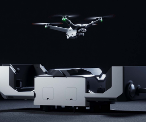
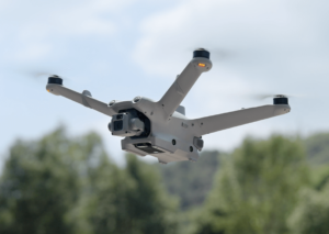
The DJI Dock 2 comes with 2 aircraft choices, the M3D and M3TD. The M3D series aircraft is designed and built for mapping applications. With the larger main sensor with mechanical shutter, it is well-suited for mapping missions. The M3TD series aircraft differs from the M3D with its thermal camera. Rated at 640×512 at 30fps, it is a powerful tool for public safety and inspection where temperature data is essential to the success of the application.
The box that the aircraft will be stored and charged in, the dock, is rated at IP55 and will have its own power and internet supplied when it is installed. Additionally, it will house a camera and a weather station that can provide real-time weather information.
Challenges:
The main challenges facing DJI Dock 2 are the training, deployment, and regulatory constraints. Due to the novel nature of drone-in-the-box solutions, there is a notable learning curve when it comes to the successful and effective utilization of the platform. Understanding how to use the Flight Hub 2 software, as well as all its capabilities, does take time to learn, digest, and efficiently apply.
Additionally, properly deploying the dock comes with further challenges. Specific installation requirements must be met for the aircraft to operate nominally. For example, the base it is installed on cannot be more than 3 degrees off, or that it must be specially grounded. Fortunately, installing docks becomes easier once you have completed a few successful installations.
Finally, one of the most limiting capacities for the dock is the regulatory considerations. For an aircraft to be remotely operated, the operator must have a Beyond Visual Line of Sight (BVLOS) waiver. Without this regulatory waiver, dock 2 will only be allowed to operate if there is a remote operator nearby that can see it. Fortunately, DJI has been working closely with the FAA and has developed a special template that an operator can fill out to obtain a BVLOS waiver. This is called “BVLOS Shielded”, which allows the aircraft to be operated remotely if the aircraft is within 50 feet of something (i.e tree, power line, building, etc).
In Conclusion:
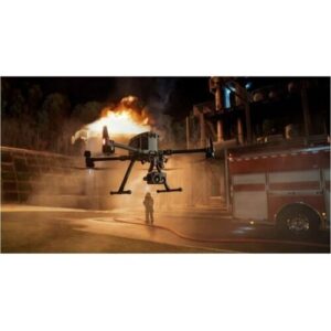
The DJI Dock 2 is an excellent platform purpose-built for remote monitoring and remote data collection. Utilizing the Flight Hub 2 web-based interface, users from around the world can conduct mapping missions, remote monitoring, inspection, drone as a first responder, as well as a host of other applications. Once the regulatory constraints are met, the Dock 2 is ready to scale to any size of operation, providing safe, efficient, and effective data collection empowering users to conduct missions with confidence and ease.

 Along with the new DJI Dock 2, there are two products at the heart of DJI innovation: the

 Getting involved in the Drone Solutions category is a low-cost way to enter this new market with significant demonstrated growth and opportunity. We are here to help AV integrators get their feet on the ground in this area by providing subject matter expertise and content training to help quickly bring an integrator up to speed.
 In the drone solutions space, there now exists two new certifications: Blue and Green UAS.
 A Green UAS is a subset of cybersecurity certification offered by AUVSI. Green UAS is designed to encompass drones that may not necessarily be manufactured in the US, but rather in allied countries. The Green UAS certification follows closely behind the DIU Blue UAS certification 2.0 program. Meaning, the Green UAS certified aircraft are essentially the same as Blue minus their country of origin.