Photogrammetry Crash Course with DJI

What is Photogrammetry?

According to NOAA, Photogrammetry is a method of approximating a three-dimensional (3D) structure using two dimensional images. Photographs are stitched together using photogrammetry software to make the 3D model and other products like photomosaic maps.

How Does That Apply to Drones?

Drones are able to rapidly capture high resolution images spanning great distances across dynamic landscapes. They can collect images of roads, hills, mountains, infrastructure, buildings – essentially any 3-dimensional objects, and turn them into high resolution 3D maps.

Where Does DJI Fit In?

DJI has several product offerings tailored to Photogrammetry applications. The Mavic 3 Enterprise (with the RTK accessory), Mavic 3 Multi-Spectral, Matrice 3D, and M350 with the P1 Payload. Pair these aircraft with the DJI RTK-2 Base Station, and you can conduct accurate centimeter level topographic surveys.

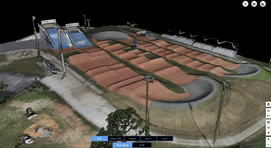
Paired with DJI Terra, you can fly the mission, import the data, hit run, and generate a precise, highly detailed 3D model of whatever you like! Buildings, infrastructure, police accident scene recreation, there are all kinds of ways to utilize 3-dimensional data in real world scenarios.

What are some examples?

Photogrammetric 3D models are used in a variety of applications. Some examples include mining, construction, agriculture, mapping, geology, police investigation, and forestry management. With plenty more to be investigated and discovered. Any place there is a need for 3-dimensional analysis, there’s a high chance that drones and photogrammetry software will be the most efficient and cheapest option!

An example of a processed Model:
Want to Know More?

In the mining industry, drones are pivotal in improving safety, efficiency, and site evaluation. By conducting aerial surveys and utilizing advanced mapping technology, drones offer a detailed view of mining operations, terrain challenges, and resource distribution. This information is crucial for site planning, optimizing the extraction process, and monitoring environmental impact.

Explore the many drone applications and use cases at Drones.ExertisAlmo.com.

If you enjoyed this blog post, check out another of Connor’s blogs on Drones in Public Safety.

Robert Voorhees
About the Author

Connor Smith

Business Development Manager

Supported Manufacturer: DJI

DJI Dock 2: Everything You Need To Know About This Autonomous Drone Nest

What is the Dock?

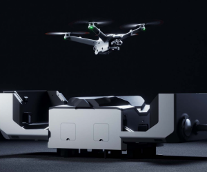
DJI Dock 2 is a complete remote, autonomous drone-in-a-box platform designed for commercial inspection, monitoring, and public safety applications. Utilizing the Flight Hub 2 web-based interface, users can remotely log into the system and conduct remote sensing operations from anywhere in the world. Additionally, users can live-stream, flight plan, map, and access all the data being collected by the aircraft in real-time, making it an incredibly useful platform for a variety of applications.

Main Features: DJI Nest 2

The DJI Dock 2 comes with 2 aircraft choices, the M3D and M3TD. The M3D series aircraft is designed and built for mapping applications. With the larger main sensor with mechanical shutter, it is well-suited for mapping missions. The M3TD series aircraft differs from the M3D with its thermal camera. Rated at 640×512 at 30fps, it is a powerful tool for public safety and inspection where temperature data is essential to the success of the application.

The box that the aircraft will be stored and charged in, the dock, is rated at IP55 and will have its own power and internet supplied when it is installed. Additionally, it will house a camera and a weather station that can provide real-time weather information.

Challenges:

The main challenges facing DJI Dock 2 are the training, deployment, and regulatory constraints.  Due to the novel nature of drone-in-the-box solutions, there is a notable learning curve when it comes to the successful and effective utilization of the platform. Understanding how to use the Flight Hub 2 software, as well as all its capabilities, does take time to learn, digest, and efficiently apply.

Additionally, properly deploying the dock comes with further challenges. Specific installation requirements must be met for the aircraft to operate nominally. For example, the base it is installed on cannot be more than 3 degrees off, or that it must be specially grounded. Fortunately, installing docks becomes easier once you have completed a few successful installations.

Finally, one of the most limiting capacities for the dock is the regulatory considerations. For an aircraft to be remotely operated, the operator must have a Beyond Visual Line of Sight (BVLOS) waiver. Without this regulatory waiver, dock 2 will only be allowed to operate if there is a remote operator nearby that can see it. Fortunately, DJI has been working closely with the FAA and has developed a special template that an operator can fill out to obtain a BVLOS waiver. This is called “BVLOS Shielded”, which allows the aircraft to be operated remotely if the aircraft is within 50 feet of something (i.e tree, power line, building, etc).

In Conclusion:

The DJI Dock 2 is an excellent platform purpose-built for remote monitoring and remote data collection. Utilizing the Flight Hub 2 web-based interface, users from around the world can conduct mapping missions, remote monitoring, inspection, drone as a first responder, as well as a host of other applications. Once the regulatory constraints are met, the Dock 2 is ready to scale to any size of operation, providing safe, efficient, and effective data collection empowering users to conduct missions with confidence and ease.

Robert Voorhees
About the Author

Connor Smith

Business Development Manager

Supported Manufacturer: DJI

Drones In Public Safety: Thermal Benefits and Uses

Introduction

Alongside the dynamic and rapidly evolving technology of Unmanned Aircraft Systems (UAS), or drones, are numerous potential applications. An effect of this evolution of technological capability is the adoption of more refined payload technologies. Beyond typical RGB Cameras, the UAS industry is experiencing the incorporation and integration of far more advanced technologies like Multi-Spectral, LiDAR, Infra-Red, Thermal, etc. This translates to greater diversity, utility capabilities, and adoption of these aircraft within developing verticals.

UAS Tech in Public Safety Overview

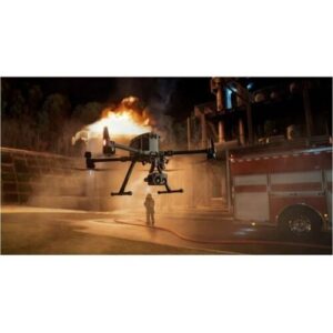
One of the prominent verticals that receives immediate benefits of the advantages of UAS is Public Safety. With the adoption of UAS technologies, first responders can immediately expand, complement, and enhance their capabilities.

DJI drone thermal imagingThermal

Up front, the immediate obvious use of UAS in public safety is their imaging capabilities. Something as simple as having a camera providing situational awareness can be of immense value in responding to calls. With the reduction in the cost and size of thermal cameras, this benefit is doubled – providing access to additional information.

What Is Thermal and Why Does it Matter for Public Safety?

Thermal imagers measure the emissivity of an object. Emissivity is the measurement of how much heat is radiating from an object. Almost everything on Earth is emissive, and the difference between the temperature of objects is where thermal imaging shines. From a public safety standpoint, this translates to locating lost persons in low light conditions and finding hot spots in firefighting.

Robert Voorhees
About the Author

Connor Smith

Business Development Manager

Supported Manufacturer: DJI

What is NDAA, Blue, and Green UAS?

What are some issues that resellers face when sourcing and selling drones?

With the advent of the availability, affordability, and ease of use of small, unmanned aircraft systems, a new market is coming into fruition. Most people have heard of drones in one way or another, often from the perspective of a small drone with a camera attached to it for use in photography. What happened in the drone space was that these new, cheaper, more affordable aircraft were being purchased and used in more and more places. Eventually, these, often Chinese, products ended up being used in data-sensitive applications. For example, military, government, security, etc. This gave rise to new cybersecurity concerns, which in turn created a new demand for an evolved product.

The National Defense Authorization Act (NDAA) is a high-level, set of federal laws passed every year targeting these growing cybersecurity concerns. In order for a product to be NDAA compliant, it must not be produced by a set list of Chinese manufacturers. Additionally, this extends beyond drones into chipsets, cameras, displays, and other technology.

Blue UAS LogoIn the drone solutions space, there now exists two new certifications: Blue and Green UAS.

A Blue UAS must meet strict hardware and operating requirements to satisfy cybersecurity demands. Some examples include video transmission encryption, aircraft operating chipset, and internet connection. Blue UAS are specifically designed to meet the cybersecurity requirements for DOD and DOI applications. An example of a Blue UAS Exertis Almo carries is the IF1200 from Inspired Flight.

Green UAS LogoA Green UAS is a subset of cybersecurity certification offered by AUVSI. Green UAS is designed to encompass drones that may not necessarily be manufactured in the US, but rather in allied countries. The Green UAS certification follows closely behind the DIU Blue UAS certification 2.0 program. Meaning, the Green UAS certified aircraft are essentially the same as Blue minus their country of origin.

With the rapid advancement, availability, and affordability of drones, the industry is evolving quickly. For applications with high levels of cybersecurity demands, often seen in government and military projects, the drone space now has a clear and emerging industry certification. What started off as NDAA, has now grown out into Blue and Green UAS.

If you’d like to know more about the drone solutions available from Exertis Almo, contact our experts today.

Robert Voorhees
About the Author

Connor Smith

Business Development Manager

Supported Manufacturer: DJI

Pin It on Pinterest