What is Photogrammetry?
According to NOAA, Photogrammetry is a method of approximating a three-dimensional (3D) structure using two dimensional images. Photographs are stitched together using photogrammetry software to make the 3D model and other products like photomosaic maps.
How Does That Apply to Drones?
Drones are able to rapidly capture high resolution images spanning great distances across dynamic landscapes. They can collect images of roads, hills, mountains, infrastructure, buildings – essentially any 3-dimensional objects, and turn them into high resolution 3D maps.
Where Does DJI Fit In?
DJI has several product offerings tailored to Photogrammetry applications. The Mavic 3 Enterprise (with the RTK accessory), Mavic 3 Multi-Spectral, Matrice 3D, and M350 with the P1 Payload. Pair these aircraft with the DJI RTK-2 Base Station, and you can conduct accurate centimeter level topographic surveys.
Paired with DJI Terra, you can fly the mission, import the data, hit run, and generate a precise, highly detailed 3D model of whatever you like! Buildings, infrastructure, police accident scene recreation, there are all kinds of ways to utilize 3-dimensional data in real world scenarios.
What are some examples?
Photogrammetric 3D models are used in a variety of applications. Some examples include mining, construction, agriculture, mapping, geology, police investigation, and forestry management. With plenty more to be investigated and discovered. Any place there is a need for 3-dimensional analysis, there’s a high chance that drones and photogrammetry software will be the most efficient and cheapest option!
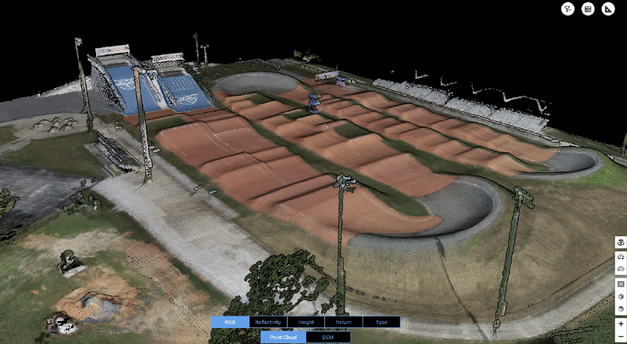
An example of a processed Model:

Want to Know More?
In the mining industry, drones are pivotal in improving safety, efficiency, and site evaluation. By conducting aerial surveys and utilizing advanced mapping technology, drones offer a detailed view of mining operations, terrain challenges, and resource distribution. This information is crucial for site planning, optimizing the extraction process, and monitoring environmental impact.
Explore the many drone applications and use cases at Drones.ExertisAlmo.com.


